
Cape York
- Jun 9, 2018
- 4 min read
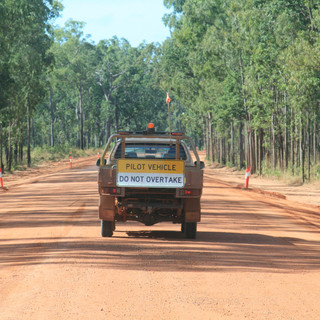
Leaving Weipa we had planned a 2 day trip as the road is pretty intense when you are pulling a caravan. We experienced first hand what idiots there can be on the road - overtaken on double lines on a blind corner and then the same guy (he had to pull onto the side of the road to check his map), overtook us again on another corner with a roadtrain heading straight towards us!! Any way, we decided to take the Batavia Downs road - a short cut across to the PDR (Peninsula Development Road). This was a really good road with a couple of small water crossings. We passed through the Batavia Downs Station as well. The road from here north was pretty good, a few dips and some roadworks but fairly good going until 35km north of Fruit Bat Falls - then it was hell!!
We spent the night at Bramwell Station. This is the most northern station in Australia around 1,500 square kilometers and runs around 5,000 head of cattle - mixture of Shorthorn and Brahman. $35 per night or $95 including all you can eat dinner - yes the food was good and they do have live music as well. They have good old bush showers (I think they are cold water showers) and also nice hot showers which after a day on the red dirt you want!
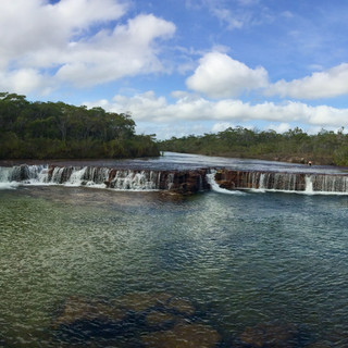
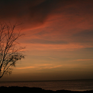
Up early and we headed to our destination in the Cape area, Alau - an Aboriginal Community run campground which overlooks Prince of Wales Island and Red Island. $10 per adult with basic facilities but they were clean and had hot running water, washing machines and if you wanted power and water these were available for an extra $8 per night. We picked a spot right on the beach - always on the look out for the small 3metre local croc of course!! The sunset here was beautiful as well. On our drive we stopped into the beautiful Fruit Bat Falls where Trent had a quick dip before we headed on. 35km north of here - about 15km south of the Jardine Ferry we hit 'hell'!! The corrugation along the stretch to the ferry was pretty rough going - down to around 20km/ph so it was along slow drive - mini moguls we called them!! The ferry was $130 for the car and van - $100 just for a car and took all of about 3 minutes to cross the river inclduging getting on and off the ferry!


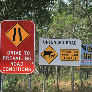
The road from north of the Jardine Ferry is also rough but it is not as bad as south of the Ferry. Just make sure your tire pressure is down and you take your time - this will help to eliminate any unwanted accidents or repairs! The roads up in the Cape are rough at the southern end but north heading to the Cape itself, they have been graded excluding the road to Loyalty Beach and Punsand - Punsand especially this is still full of washouts.


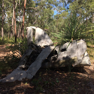
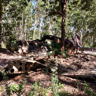
We went out to the airport to see the WWII plane that had crashed into the forest, the fuel dump - lots of old empty gas containers and also a DC3 which crashed into the forest after leaving Brisbane for New Guinea in 1945. These sites are difficult to find as they are not well sign posted - look for a tree with a sign in it!


We headed out to do some exploring of the area - Seisia to the wharf which according to locals is one of 2 significant fishing areas in Australia, Loyalty Beach, Punsand, Somerset and of course to Cape York or Parinka as its known.
Loyalty Beach is just the camping ground as is Punsand. Both these places have the organised tours staying here - Punsand has a full restaurant and live music. Seisia campground is massive and is on the beach and also across the road from the main camping ground. Most of the Cape area is under developed which was pretty surprising given the number of Australians especially who flock here. There is a supermarket in Seisia and a number of petrol stations around - fuel ranged from $1.80 along the PDR to $2.06 in Seisia per litre.


The roads in and around Seisia are sealed but heading up to the Cape it is back to the reddirt! The road to the Cape is pretty in places, winding through the rainforest, in parts you are unable to see the sky as it is fully enclosed around you. The road is also narrow - be careful idiots drive like they are on a race track in sections where you can't see them coming!! There is also a small river crossing - take your time and follow the tracks of others.
Once at Parinka, it is a bit of a walk - either along the beach(low tide only) and up over the rocks to the tip or like us, clamber the rocks from start to finish! Georgia came along the rock route with us. The view at the top is pretty awesome - you can see for miles and miles! The ocean was gleaming in the sunshine and the water looked amazing too. It is a shame you can't swim here because of the crocs as it looks very inviting. There were people fishing off the tip while we were there.
Some people kindly took our picture to prove It is actually a nice walk along the rocks taking it all in. Dogs are allowed up here as it is not National Park. There were a number of people doing the pilgrimage the same as us so don't be surprised if you have to wait to take your photo! We had made it!


Comments